National Parks and Nature Reserves of Baikal
People came to the understanding that it is necessary to actively protect nature from people themselves some time ago¬Ý‚Äî way back in the 19th century. It can't be said that since then it has been possible to succeed perceptibly in this good work, but thanks to the conservation movement some relatively wild areas of the earth have been preserved.
Nature conservation organisations in the Lake Baikal basin are represented by nature reserves (zapovedniks), national parks and reserves (zakazniks). Below, I have tried to gather together some basic information on the protected territories adjacent to Baikal's shores. The position and boundaries of these protected territories can be seen on the map.
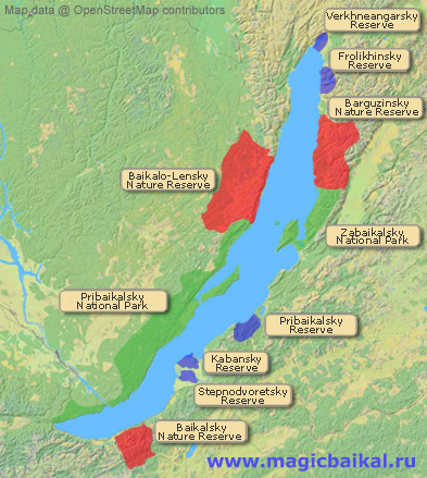 Map of nature conservation organisations situated on the shores of Lake Baikal: nature reserves, national parks and reserves.
There are three nature reserves (zapovedniks) immediately adjacent to Lake Baikal:
Two national parks:
And six reserves (zakazniks):
- Frolikhinsky reserve
- Kabansky reserve
- Pribaikalsky reserve
- Stepnodvoretsky reserve
- Verkhneangarsky reserve
- Enkhelutsky reserve
All nature conservation organisations have a fee for visiting their territories.
Nature Reserves of Baikal
Nature reserves are conservation organisations whose main task is to preserve the nature of their territory in its natural state. All nature reserves are protected territories with federal status. The presence of outsiders in nature reserves is not welcome and it is necessary to get a permit from its administration for passage through its territory. This should be seen to beforehand if possible. If this is not possible, it is necessary to get a permit at the reserve's cordon but this is not always possible. For example, permits are not issued at the cordons of the Barguzinsky nature reserve.
The Barguzinsky Nature Reserve
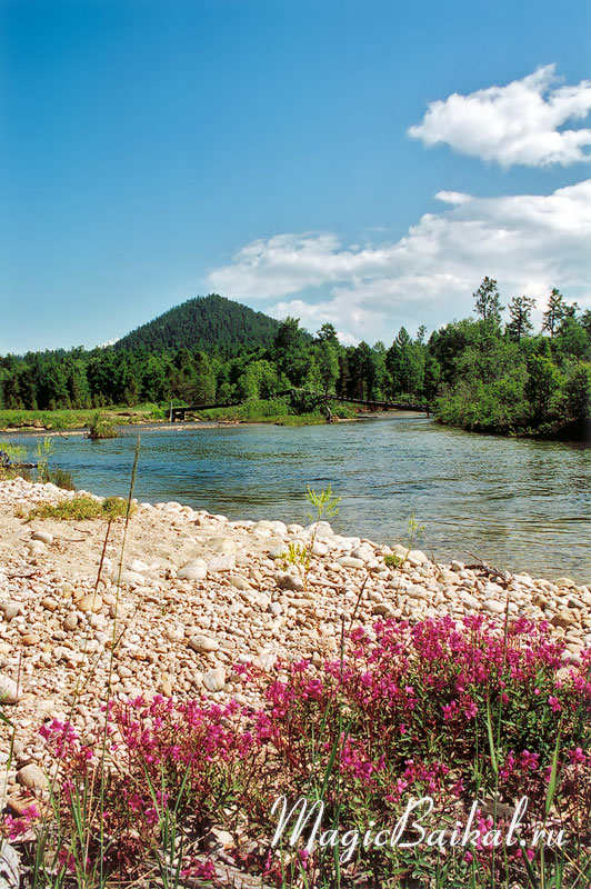 The Barguzinsky Nature Reserve. Tarkulik river.
The Barguzinsky state biosphere nature reserve is one of the oldest of its kind in Russia. It was created with the aim of conserving the sable population. Its territory includes the nature reserve itself (2631¬Ýkm2) and biosphere buffer zone (1112¬Ýkm2).
The northern limits of the Barguzinsky nature reserve pass along the divide between the rivers Shegnanda and Irinda, while the southern boundary goes along the divide on the left bank of the river Shumilikhi, the eastern along the ridge of the main Barguzine range, and the western across the waters of Baikal itself three kilometers from the shoreline. The length of the Barguzinsky nature reserve along Baikal's shores is some 100 kilometres.
The cordons of the Barguzinsky nature reserve are situated on Capes Shegnanda and Kabany, a kilometre to the north of the mouth of the river Bolshaya and in Sosnovka bay.
To pass through the nature reserve it is essential to get permission from the directorate and to learn where it is permitted to make camp from the nature reserve's inspectors. In the buffer zone it is possible to make camp almost anywhere between the mouths of the rivers Shegnanda and Kabanya. Within the territory of the nature reserve itself, camps are permitted only in four places: at the mouth of the river Kabanya, or at the cordon a little to the south of the river mouth, at the cordon close to the mouth of the river Bolshaya, in the settlement of Davsha, and in Sosnovka bay.
| Date of foundation: | 17th May 1916. |
| Area: | 3743 km2. |
| Geographical location: | The eastern shores of Lake Baikal, Republic of Buryatia, western slopes of the Barguzine mountain range. |
The nature reserve's permanent on–site base is in the settlement of Davsha, while its scientific centre is in Ulan–Ude. The nature reserve's Natural History Museum is in the settlement of Davsha.
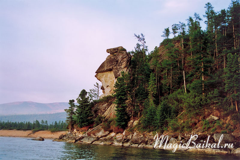
The Baikalo–Lenskiy Nature Reserve
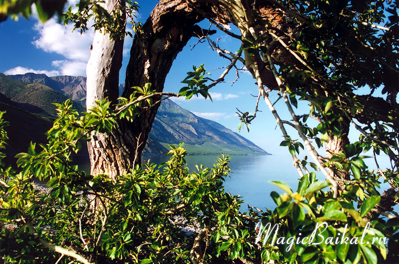 The Baikalo–Lenskiy Nature Reserve. On cape Rytyi.
The Baikalo‚ÄìLenskiy Nature Reserve. On cape Rytyi.The largest and youngest of Baikal's nature reserves. To the north, the reserve is bounded by Cape Elokhin, in the south by the river Kheirem. Its length from Cape Elokhin to the river Kheirem is 110 kilometres. But not all the shoreline is included in the reserve¬Ý‚Äî a 24 kilometre long section to the south of Cape Severny Kedrovy is not part of Baikalo‚ÄìLenskiy territory.
The Baikalo–Lenskiy nature reserve cordons are at Capes Elokhin, Pokoiniki and Kocherikovsky.
| Date of foundation: | 5th December 1986. |
| Area: | 6600 km2. |
| Geographical location: | The western shores of Lake Baikal, Kachug and Olkhon districts of Irkutsk Oblast, southern part of the Baikalskiy mountain range. |
The Baikalskiy Nature Reserve
The Baikalskiy Nature Reserve is the only Baikal reserve that does not extend to the shores of the lake; the northern boundary of the reserve is formed by the artificial barriers of the main road and the railway that extend along the shores of Lake Baikal. The eastern limits of the Baikalskiy reserve pass along the valley of the river Levaya Mishikha, while its western border passes through the valley of the river Vydrinaya. The reserve stretches some 60 kilometres adjacent to the shores of the lake.
The reserve was set up with the aim of conserving the unique nature of the Khamar‚ÄìDaban mountain range, now, however, the impact of emissions from the Baikalsk pulp and paper mill on the reserve's forests has to be studied. The reserve is surrounded by a buffer zone from 0.5 to 4 kilometres wide, covering some 348¬Ýkm2.
There is a Natural History Museum in the reserve.
| Date of foundation: | September 1969. |
| Area: | 1657 km2. |
| Geographical location: | The south–eastern shores of Lake Baikal, Republic of Buryatia, central part of the Khamar–Daban mountain range. |
National Parks
National parks were set up with the aim of preserving natural complexes and sites having particular ecological, historical and aesthetic value, and to create the conditions for regular tourism and recreation. Like the nature reserves, national parks are specially protected territories of federal status. The territory of a national park can be divided into zones such as, for example, nature reserve, for recreational and educational tourism, visitor service centres, traditional land use, and resource status etc. It is important to note that in the nature reserve zone the level of protection is the same as for nature reserves.
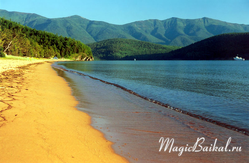
Pribaikalskiy National Park
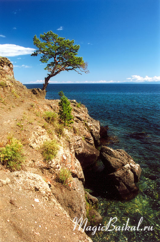 Baikal's shore. Pribaikalskiy National Park.
The Pribaikalskiy National Park occupies 450 kilometres of Baikal's coastline from the southernmost end of the lake to the river Kheirem¬Ý‚Äî the southern border of the Baikalo‚ÄìLenskiy nature reserve. The Island of Olkhon and all the islands of the Maloye Morye are also part of the national park.
| Date of foundation: | 13th February 1986. |
| Area: | 4183 km2. |
| Geographical location: | Western shores of Lake Baikal, Irkutsk, Olkhon, and Sliudyanskiy districts of Irkutsk Oblast, the south and south–eastern slopes of the Primorskiy mountain range. |
Zabaikalskiy National Park
 Zabaikalskiy National Park. Zmeinaya (snake) Bay.
The Zabaikalskiy National Park is situated on the eastern shores of Lake Baikal adjacent to the southern borders of the Barguzinsky Nature Reserve. The southern boundary of the park is at the river Barguzine (the river itself is not part of park territory). The park was set up with the aim of preserving the nature of Zabaikalye, the haul–outs of the Baikal seal (nerpa) at the Ushkany islands and the waterfowl of lake Arangatui.
Apart from the shores of Baikal, the protected area includes the Ushkany island archipelago and 370¬Ýkm2 of the lake itself. Some 40% of the park has nature reserve status. This includes the area to the north of the river Bolshoi Chiverkui, the Ushkany islands, the islands of Chiverkuiskiy Bay, the area of the Svyatoi Nos Peninsular to the north of Cape Zmeievy and to the south of Cape Osinovy. Apart from this, the part of Lake Baikal close to the Island of Baklany, along Ongokonskaya, Fertik and Molodost Bays.
The length of Zabaikalskiy National Park along Baikal's shoreline is some 240 kilometres.
| Date of foundation: | 12th September 1986. |
| Area: | 2691 km2. |
| Geographical location: | Eastern shores of Lake Baikal, Republic of Buryatia, Barguzinsky district, western slopes of the Barguzine mountain range. |
Reserves
Reserves are areas with special significance for the conservation of natural complexes and maintenance of the ecological balance. Reserves can have federal or regional status.
Frolikhinskiy Reserve
 Frolikhinskiy Reserve. Khaman–Kit Cape.
The Frolikhinskiy Reserve was set up with the aim of preserving wildlife populations and their breeding grounds.
The Reserve includes part of Lake Baikal's shoreline from Cape Nemnyanka in the north to the river Shirildy in the south (some 45 kilometres of shoreline).
| Date of foundation: | 5th January 1988. |
| Status: | Federal. |
| Area: | 1090 km2. |
| Geographical location: | North–eastern shores of Lake Baikal, Republic of Buryatia. |
Kabanskiy Reserve
The Kabanskiy Reserve is situated on the eastern shores of Lake Baikal in the delta of the river Selenga. It was created with the aim of preserving waterfowl and their habitat. The reserve has federal status and since 1985 has been a branch of the Baikalskiy Nature Reserve. Part of the Selenga delta, the territory of the reserve comes under the scope of the Ramsar Convention on Wetlands.
| Date of foundation: | 1967. |
| Status: | Federal. |
| Area: | 180 km2. |
| Geographical location: | Eastern shores of Lake Baikal, Republic of Buryatia, Kabanskiy district, delta of the river Selenga. |
Pribaikalskiy Reserve
The Pribaikalskiy Reserve was set up for the conservation and restoration of wildlife populations.
| Date of foundation: | Status:28th April 1981. |
| Status: | Regional. |
| Area: | 701 km2. |
| Geographical location: | Eastern shores of Lake Baikal, Republic of Buryatia, Pribaikalskiy district. |
Stepnodvoretskiy Reserve
The reserve was established for the reproduction and conservation of the Siberian roe deer and other wildlife.
| Date of foundation: | 1975. |
| Status: | Regional. |
| Area: | 150 km2. |
| Geographical location: | Eastern shores of Lake Baikal, Republic of Buryatia, Kabanskiy district. |
Verkhneangarskiy Reserve
This regional ornithological reserve was set up to protect waterfowl and their habitat.
| Date of foundation: | 1979. |
| Status: | Regional. |
| Area: | 245 km2. |
| Geographical location: | Northern shores of Lake Baikal, Republic of Buryatia, eastern part of the delta of the river Verkhnaya Angara. |
Enkhelukskiy Reserve
The reserve was established with the aim of conservation, breeding and restoration of wildlife of economic, scientific and cultural interest.
| Date of foundation: | 1995. |
| Status: | Regional. |
| Area: | 123 km2. |
| Geographical location: | Eastern shores of Lake Baikal, Republic of Buryatia, Kabanskiy district. |
© Magic Baikal