The Island of Olkhon
Amongst the thirty of so islands of Baikal, the island of Olkhon, surrounded by many ancient myths and legends, can especially be singled out¬†‚ÄĒ for its size, variety of landscape and magnificence of natural monuments. Olkhon is part of the Pribaikalskiy National Park and is deservedly considered to be one of the most beautiful places at Baikal. The island is particularly beautiful in the autumn when the shores are practically deserted. Covered in a golden carpet of grasses, with forests touched by the fiery colours of autumn, Olkhon dutifully comes to a standstill under the battering of mighty waves and mountain wind in expectation of the severe Siberian winter...
The geography of Olkhon
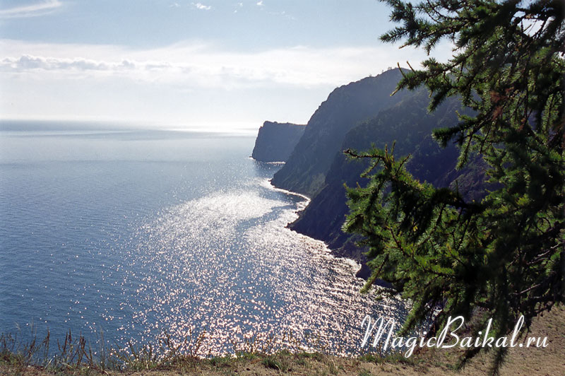
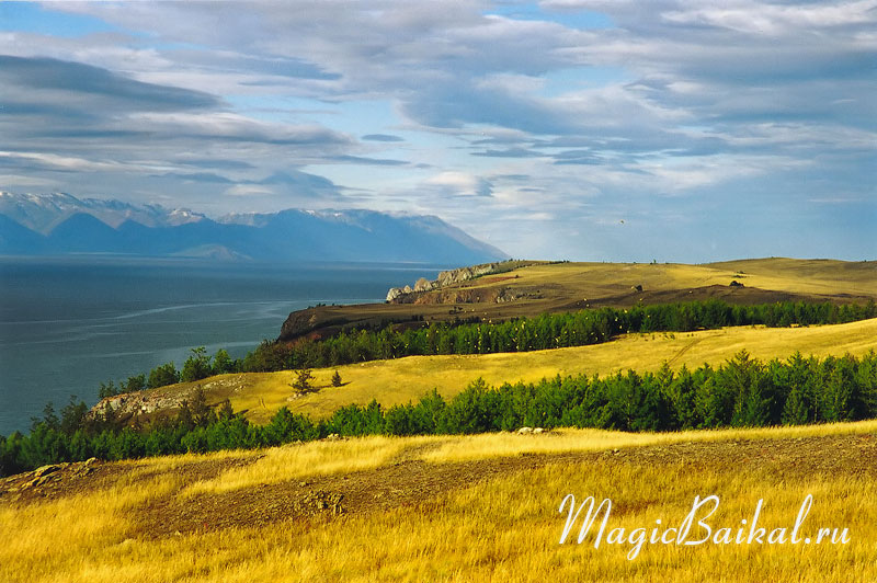 Autumn on Olkhon. Olkhon's north coast.
Olkhon, Baikal's largest island, is situated in its central part near the western coast. The island stretches out along the lake's coast, 73 km long and 15 km wide at its widest, with an area of some 700 km.
The part of Baikal enclosed between the west coast of the lake and the island itself, is a unique space of water with its own microclimate. Its name, Maloye Morye (Small Sea) speaks of its exclusiveness and well known independence. The western end of Olkhon is separated from Baikal's shores by the Olkhonskiye Vorota straits, that have the reputation of being the most treacherous place on the lake.
There are at least two versions as to the origin of the island's name, both of which spring from the language of its native peoples¬†‚ÄĒ the Buryat. The first version has it that the island's name came from the word ¬ęoikhon¬Ľ¬†‚ÄĒ wooded, while according the second, it comes from the word ¬ęolhan¬Ľ¬†‚ÄĒ ¬ędry¬Ľ. Both fit Olkhon's character perfectly: it is at once dry and wooded, so it is difficult to give preference to one or other version.
The western coast of the island of Olkhon, washed by the waters of the Maloye Morye, are in the main sloping with rocky promontories and deep bays cutting into the land. The eastern, on the other hand, is mountainous, plunging steeply into Baikal. There are no deep bays here.
It is on the southern side of the island that its highest point is situated¬†‚ÄĒ the mountain Zhima (1274 metres), rising 818 metres above Baikal. And only 11 kilometres from the highest point on Olkhon is the deepest part of the lake¬†‚ÄĒ at 1637 metres. In these places, the steepness of underwater slopes is up to 30‚Äď40 degrees.
The southern part of the island and, partly, its northern end are steppe, while the remainder of the island is covered in pine, larch and birch forests. In the central part of the northern coast, beginning at Cape Khuzhir up till Cape Sasa, the shores are sandy. Covered with pine and larch, cleaved by rocky promontories, they leave an unforgettable impression.
Olkhon is large enough to have its own lakes. The largest and best known being Nurskoye, merging into the Zagli bay at high water on Baikal; Khankhoy, with a whole necklace of archaeological sites; Shara‚ÄďNur, the only saline lake on Olkhon; and Nuku‚ÄďNur, with its incredibly rich underwater life.
There are no rivers on Olkhon, and only two small streams are known whose waters reach Baikal. The forested part of the island has small springs that feed a small number of marshes. Despite the dryness, new streams are coming to light to this day. In September 2004, I discovered a stream at the northern end of the Saraiskiy bay. It was only a little smaller than the one flowing near the settlement of Kharantsy. Going up the course of the stream, I discovered that it comes from a small ravine that was apparently cut out by the stream itself. It is 100‚Äď150 metres in length.
Olkhon's climate
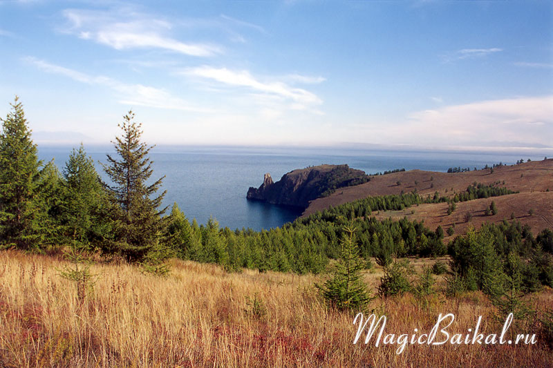 Cape Khoboy at the northern tip of Olkhon.
The warmest months on the island are July and August. Spring and summer come later than on the mainland. Winter is quite mild with little snow, but longer than on the mainland. There is very little precipitation on Olkhon, some 200¬†mm a year¬†‚ÄĒ the norm for semi‚Äďdeserts. The southern and south‚Äďwestern parts of the island are the driest, not only on the island but of all Baikal. The reason for this being the Primorskiy mountain range, over which air masses pass on their way to Olkhon. Surmounting the range and rolling down into the Baikal depression, they are warmed, so bringing about a fall in relative humidity. As a result, rains that were meant for Olkhon, fall on the eastern coast of the lake. Olkhon rain is usually a few drops an hour, but at times there can be very heavy rains, and prolonged bad weather.
It is often windy on the island and for long periods, the prevailing wind coming from the north‚Äďwest. On average, there are 148 days in the year with a wind speed of more than 15¬†m/sec. Thanks to the fact that the Olkhon is stretched out along the Primorskiy range, itself being a spur, the island gets the full force of the mountain wind, including the wildest of its kind¬†‚ÄĒ the Sarma.
The people of Olkhon
People settled on the island of Olkhon a very long time ago¬†‚ÄĒ an early human camp dating from Palaeolithic times was found in the Saraiskiy bay, estimated to be more than 13 thousand years of age. Today, Olkhon is the only inhabited island in the lake. Some 1500 people, mostly the native Buryat, live in three small settlements. The largest settlement on the island, Khuzhir, has a population of 1200. This is where the only industrial enterprise on the island is situated¬†‚ÄĒ the largest, Malomorsky, fish factory on Baikal.
Flora and fauna
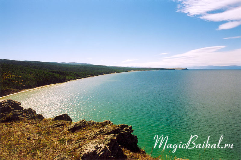 Niurgansk Bay. View from Cape Sasa. Olkhon's north coast.
Wildlife on Olkhon has suffered to a considerable extent from intense human impact. Even the game reserve ¬ęOlkhonsky¬Ľ, specially established in 1977, encompassing almost all the forest zone of the island, failed to help. Humans are to blame for the disappearance of the cormorant, bustard, wolf, Siberian deer, roe deer, and the plasterer's hawk from the island over the last few decades. Even way back in the 18th century sable was exterminated on Olkhon. The Baikal seal, so loving to warm itself on the rocks by the shore, has become a rarity. One can find this unique animal now only on the eastern shores of the island. Quite recently, the imperial eagle, once nesting here, has disappeared entirely¬†‚ÄĒ that is the same sacred ¬ęwhite headed eagle¬Ľ, hero of many ancient Baikal legends, son of the Lord of Olkhon, forebear of Olkhon shamans, to whom offerings are still made.
Today, 135 species of bird inhabit the island (sandpipers, duck, black grouse, capercaillie, Daurian jackdaw, horned lark, white‚Äďthroated swift, wheatear, wagtail etc.). Twenty species of mammal (lynx, fox, hare, squirrel, polecat, weasel and others), including the little native (endemic) Olkhon field‚Äďmouse that is found only in the Pribaikal steppe; three species of reptile and one amphibian. Of the large predators, on rare occasions, single wolves can be found in winter that have come to the island over the ice. Only on very rare occasions do wolf packs visit the island in this way. There are no bears on Olkhon.
Archaeology
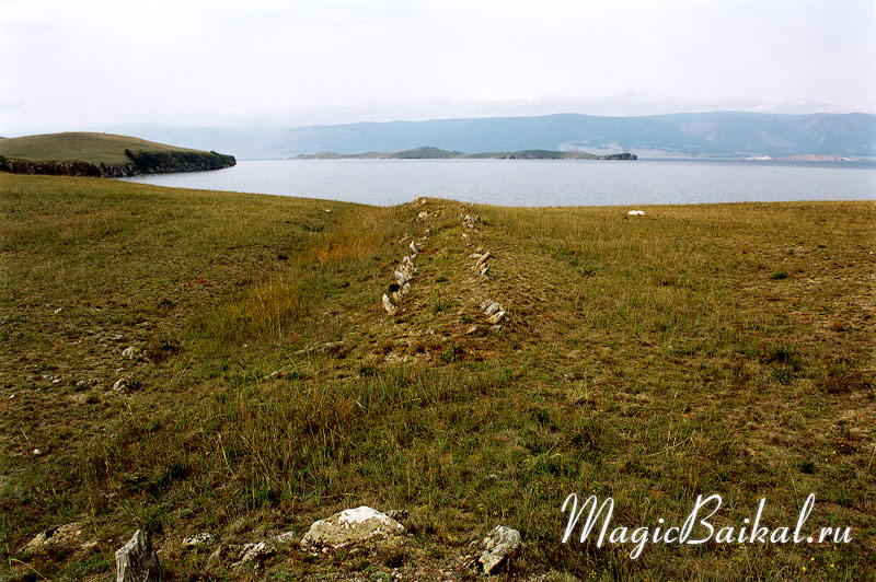 The remains of a stone wall on Cape Shara Shulun. Olkhon's north coast.
Olkhon's history finds its roots deep in the past. The island has given rise to many remarkable legends and tales. Numerous historical cairns and archaeological finds, made over more than 200 years of study, witness to this rich history. As of January 1st 1993, 143 archaeological sites, many of which are protected by the state, were known on the island: rock paintings, ancient settlements, camps, burial sites, religious and defensive works. Unfortunately, many archaeological sites have been destroyed, including some of the more significant: ancient stone walls the purpose of which is still unknown for certain. On the other hand, it is well known with what aim they were destroyed in 1963¬†‚ÄĒ the stones were used to strengthen the pier in the settlement of Khuzhir.
Olkhon's environment
 Cliffs of Olkhon's southern coast.
Accessibility and uniqueness paid poor service to Olkhon. The anthropogenic load, especially on the north‚Äďwestern coast of the island, is beyond all reasonable limits. The islands steppe suffer from vehicles¬†‚ÄĒ drivers don't think it necessary to stick to the road ruts. This causes severe erosion of the soil. As a matter of fact, to a greater or lesser extent, everyone makes a contribution to the destruction of Olkhon's unique natural world, from the vandals who perfect their artistic skills on the island's cliffs to the archaeologists that make little effort to cover the traces of their excavations. In recent years fires have become more frequent.
Olkhon's natural monuments
There are a number of natural monuments on the island protected by the state, though, in truth, it is time that the whole island be declared a natural monument and real protection began.
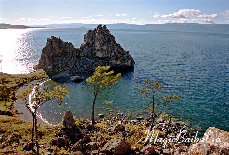 Cape Shaman (Burkhan). Olkhon's north coast.
The best known natural monument of Lake Baikal is Cape Burkhan, or Cape Shaman, considered a natural‚Äďhistorical monument. Burkhan is situation in the central part of the north‚Äďwestern coast of the island, at the edge of the settlement of Khuzhir. The image of this cape has almost become the visiting card of Baikal.
No less impressive are the natural monument‚Äďlandscapes of Cape Sagan‚ÄďKhushun¬†‚ÄĒ a wonderful white marble promontory in the northern part of the island, and Cape Khoboy, crowning Olkhon's northern tip.
The striking Cape Kobylya Golova (mare's head), washed on one side by the waters of the Maloye Morye, and on the other by the waters of the Olkhonskiye Vorota Strait, has been declared a geological and geomorphologic natural monument.
Botanical monuments are represented by a relict fir‚Äďwood on the western slope of Zhima mountain. The fir‚Äďwood was discovered in 1965 by a student of local lore and teacher of geography at the Khuzhir school, Nicolai Revyakin. Its uniqueness lies in the fact that it has come down to us from the last glacial period, and has survived despite Olkhon's arid climate, thanks to the presence of subsoil waters.
Other natural monuments of special scientific interest are also protected: the geological and geomorphologic monuments of Kharansa and Kharaldaiskaya bays, Cape Sasa, the Peshanka tract, and the natural landscape‚Äďmonuments, Zagli and Tagai bays, and the Bayan‚ÄďShungen tract.
How to get to Olkhon
In summer Olkhon is linked with the mainland by a ferry service, usually working from May till December. The ferry crosses the Olkhonskiye Vorota Straits from Malaya Kurkutskaya bay on the mainland to Perevoznaya bay on the island. When the straits freeze over, a natural over‚Äďice crossing is formed. From November to January and April to May there is no link with Olkhon. There is also no link when the ferry breaks down. At the height of the summer large numbers of cars can build up at the ferry quay. One can get to Olkhon in some 5‚Äď6 hours from Irkutsk by a regular bus.
© Magic Baikal
Related links: